Tag: Travel

  • Busway consultation reveals new route bordering Impington

    Busway consultation reveals new route bordering Impington

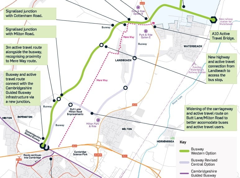
    Proposals for a new busway and active travel route connecting Waterbeach and Cambridge include two potential route options, both of which would pass through Histon & Impington to join up with the existing Guided Busway.

    This would be one of four new busways around the city linking Cambridge with the surrounding areas, all aiming to take buses off the road network to avoid congestion. The need for this is particularly pressing around Waterbeach New Town, where planned employment and housing growth will see around 9000 new homes in the coming years.

    The Greater Cambridge Partnership (GCP) is running a consultation on their busway proposals, including an in-person event in Histon on 21 February, for residents to learn more about the proposals and ask questions of the project team.

    Proposed Busway junction on Milton Road, Impington. Image: Greater Cambridge Partnership

    Route options

    The two route options for the busway both start at a relocated Waterbeach Railway Station, which will serve Waterbeach New Town as well as the existing village. They would then head across the A10, potentially to a new Park & Ride site.

    The ‘Western Option’ busway would then run south west, significantly to the west of the Mere Way boundary that marks the border between Histon & Impington and Milton.

    The route would cross fields to the west of Landbeach to reach a signalled crossing at Milton Road, Impington. After that it would pass behind the residential properties around St Andrew’s Way, and cross fields again to connect with the existing Guided Busway. A new junction would be created on the Busway to the east of the Impington bus stops on Station Road.

    Buses could then continue on into Cambridge via Histon Road or Milton Road.

    Busway option – Revised central route. Image: Greater Cambridge Partnership

    The ‘Revised Central Option’ would start on the same route from Waterbeach, but continue to the east of the Mere Way boundary and east of Landbeach, until it reaches the Milton Park & Ride site.

    At that point some buses heading south towards Cambridge would turn onto Butt Lane and continue towards Impington on Milton Road.

    Before reaching the residential edge of the village, the route would turn off south towards Cambridge, across fields, to meet the existing Guided Busway.

    Common characteristics

    For both options the route would be mainly off road, only interacting with other traffic at junctions and a short section along Butt Lane/ Milton Road. These roads would be widened and improved to make space for the buses and become more suitable for active travel.

    Junctions with Butt Lane/Milton Road – Revised central route. Image: Greater Cambridge Partnership

    Junctions between existing roads and the new Busway would be controlled by traffic lights, with bus priority built in.

    New bus stops bus could be provided around Landbeach and on Butt Lane.

    GCP envisages that both routes would be integrated with existing bus services to provide good connections, including through the Darwin Green development.

    Duplication

    Both of the proposed busway routes would run very close to Mere Way, where controversial improvements to this Public Right of Way were due to begin last year.

    Safety concerns about the plans for Mere Way – especially the absence of lighting – were raised by County Councillor Ros Hathorn, but no resolution was found. So given that new infrastructure for walking and cycling would be developed alongside both busway options being considered, is there still a need to convert this rural route to be used for active travel rather than leisure?

    Mere Way. Photo: Brian Whitehead

    HI HUB asked GCP about plans for lighting the active travel route. A spokeperson said: “We are in discussions with Cambridgeshire County Council’s Street Lighting Team to confirm the lighting strategy for the busway.

    “The current assumptions are the busway will be lit at junctions and that the active travel route may have some form of lighting, such as solar studs, along its length. The nature of the lighting is to be confirmed at the next stage of the study.”

    As for plans for a joined-up approach to the use of Mere Way and the Busway, they said: “This is not a GCP scheme, but we have had regular engagement with Urban and Civic as they have developed their plans for Mere Way. We see the two projects as both compatible and complementary to each other.”

    Have your say

    The consultation is now live and will run to midday on Friday 24 March. The findings from this will go back to GCP’s Executive Board in June, together with recommendation for a preferred route option.

    Histon & Impington residents are being encouraged to take part in the consultation by reading the consultation proposals, attending an event – either online or in person – and completing an online survey.

    The Histon & Impington event will take place at the St Andrew’s Centre on Tuesday 21 February from 4.30pm – 7.30pm.

    Online events will be held at 6pm on 9 February, 13 February and 23 February, with registration required. Full details of all the events are on the consultation home page at https://consultcambs.uk.engagementhq.com/gcp-waterbeach-to-cambridge-2023.  

    The consultation brochure can be found here.

    Other related documents, including detailed technical drawings of the proposed routes through Histon & Impington, can be found here . (See the Revised central corridor and Western corridors sections 1 and 2)

    Anyone wanting to complete a hard copy of the survey, rather than the online version, should call 01223 699906.

  • Drop-in Public Exhibition – Making Connections 2022

    Greater Cambridge Partnership is holding a public exhibition on Saturday 5th November from 10am to 1pm at the Meadows Community Centre, just south of the A14.

    Come along to hear/view more on the proposals for faster, cheaper, more reliable bus services and safer cycling through the introduction of a Sustainable Travel Zone. Have your questions answered by a member of the project team.

  • Active travel – have your say on future planning consultation

    New proposals would see the middle section of Station Road closed to motor vehicles travelling south. County Councillor Ros Hathorn urges residents to have their say in a public consultation.

    The pandemic gave us a glimpse of living in a low traffic world; families walking and cycling around the village, empty roads, low levels of traffic noise, parents more relaxed on the streets. The village felt calmer and shopping locally by bike felt good.

    I was not the only one to notice the change. Confronted with the twin perils of a national health crisis and the climate emergency the government is encouraging active travel, announcing ‘PM kickstarts £2bn cycling and walking revolution

    Among the schemes proposed – all funded by central government – is one for Histon & Impington, and a consultation is running so please get involved and share your thoughts.

    The scheme

    The section of Station Road after the Baptist church towards Firs House surgery is narrow and is normally lined with parked cars. Under the proposed scheme ‘modal filters’ will be placed on Station Road near the War Memorial/ Baptist church, and this stretch of road, by The Geographer and Firs House Surgery, will become a no through road to southbound motor vehicles.

    Cyclists, pedestrians, mobility scooter users etc will have full access, but motorists travelling south through the village from the High Street will have to detour along Bridge Road (B1049) to access this middle part of Station Road and those travelling from the south to the High Street will also, instead, have to use the B1049.  There will, however, be full access to this stretch for all vehicles from the Chequers Road/ Firs House surgery end.

    A Cambridge modal filter, using planters. Photo: Cycling Dad UK

    ‘Modal filters’ determine the types of traffic that can access a stretch of road, but are designed not to impact on emergency services access. They are positioned so that bikes, cargo bikes etc can get round them, but the road is blocked for cars and other motor vehicles. In Cambridge, some schemes use large planters for this. The Bell Hill trial has used a water filled barrier which is less attractive, but cheap and good for trialling changes. The proposals here are for a barrier on both lanes of Station Road in line with the Baptist Church car park with a water filled barrier (like on Bell Hill) blocking the southbound lane which is removable for emergency access and a barrier to stop cars and vans on the northbound lane.   

    The consultation points out that the bus stops outside the Baptist church will be lost under this scheme, and this is a downside of the proposal. If the modal filter was a camera the bus stops might be saved as it would allow bus access to continue, but this option is expensive so the consultation is important for gathering views. The loss of this bus stop is a concern and, if you think this is important, please add your voice to the request for a camera modal filter – or just express clearly how important you feel this bus stop is.

    Safer, quicker, easier

    This is not a ‘traffic scheme’, but an active travel scheme that will encourage our community to be people focussed rather than car focussed, and support people to cycle or walk.

    Although it will make some car and van journeys slightly longer, it will make active travel more attractive and the easier, quicker, choice for those who can walk and cycle. For those who rely on a car, low traffic environments are also safer as there are fewer other cars.

    Despite the infant school relocation, Station Road remains a key school route and safety is a major concern. Those cycling north towards the High Street meet a stream of drivers coming towards them, and high traffic levels at the Cambridge Road/ Bridge Road junction by the camel sculpture junction confirm that large numbers of drivers use that route as a rat run.

    For drivers on the High Street turning right at Station Road currently presents an attractive alternative to waiting for the zebra crossing and queuing at the traffic lights to join the B1049. By turning into Station Road those cars are driving head on into the flow of families cycling and walking to school. There is not enough room for cars to safely pass cyclists but they regularly try and there are many reports from parents on social media and in conversation about near misses on Station Road.

    This proposed scheme will make Station Road a significantly less attractive rat run as drivers would have to join the busy traffic on Water Lane/B1049 at the war memorial junction from an uncontrolled crossing, which can be difficult.

    Wider impact

    There are concerns that this proposal would push more traffic onto the B1049 and make other places busier, but previous road closures suggest this may not make a significant difference. The B1049/ High Street junction was closed for a number of weeks 2 years ago when the junction was modified. Whilst there were initially traffic jams at peak times, after about 3 days the traffic jams disappeared. It seemed as though those using Histon and Impington as a cut-through found alternative routes when Histon and Impington became less convenient.

    There are also implication for residents. Traffic noise will drop and the area would feel a lot calmer, so parents should feel more confident about their children moving freely in the space. Residents will, though, have to drive further to access the centre of the village.

    For wheelchair users, mobility scooter users and those with mobility issues, these measures should make this stretch a more pleasant accessible space to move around. If crossing the road is challenging – for example with a large buggy or if you move slowly – it is easier in a low traffic environment. On the downside, some disabled drivers will have to drive slightly further.

    Neighbourhood plan

    The neighbourhood plan was recently voted through with over 90% of voters in favour. A community where people walked and cycled locally was a key theme. The shift to active travel will not just magically happen, we need to restructure where we live. Our spaces must be people not car focussed.

    On this basis, my assessment is that the positives significantly outweigh the negatives:

    • Station Road Dental surgery – no negative impact
    • Firs House Doctors surgery – no negative impact
    • Pharmacy – possibly some impact, but trade is closely connected to prescriptions from Firs House
    • The Geographer (sadly now closed) was always largely used by locals. Whilst there may be some impact on passing trade, these changes would also create new opportunities. The outside area was always well used and there may be an opportunity to spread tables further onto the road in a low traffic environment.

    If you have strong feelings about this proposal please comment on the consultation now. This is your opportunity to have a say make your voice heard. Consultation closes 24 August 2021.

    Access the consultation online at https://consultcambs.uk.engagementhq.com/cats

  • Histon & Impington part of ‘active travel’ review

    Improvements to the walking and cycling routes joining Histon and Impington with Cambridge and Milton have not been identified as top priorities, but the public now has the chance to influence investment decisions.

    A £20m budget for boosting ‘active travel’ around Cambridge and South Cambridgeshire now looks unlikely to benefit Histon and Impington, despite two routes out of the village having been shortlisted for investment.

    The Greater Cambridge Partnership (GCP) has earmarked the money for key travel ‘corridors’ around and into the city, where improving cycling and walking infrastructure could encourage people to stop using their cars or other motorised forms of transport.

    Among the 13 busy ‘corridors’ identified were Histon to Histon Road, Cambridge, and from Impington to Milton. These are among 5 rural corridors where daily cycle trips number over 1,000 a day. A further 8 ‘City Corridors’ were identified within Cambridge itself.

    However, the limited budget means the GCP will only be able to fund schemes on two or three of the 13 identified corridors and a review of the evidence has found that routes in the City of Cambridge itself generally offer better value for money due to the number of people who use them.

    The review recommends implementing two schemes connecting to the controversial £2.3m Dutch-style roundabout on the A1134 near Addenbrookes in Cambridge, which together will take all of the allocated £20m budget. It suggests that improvements to the 11 other busy travel corridors, including the £1.5m Impington to Milton proposals, and the £2.9m Histon scheme, are “used as an ongoing reference and be reflected on should additional funding opportunities present themselves”.

    Histon & Impington proposals

    Despite having been improved in recent years, the cycle route from the New Road/Bridge Road junction in Impington to the Butt Lane/ Park & Ride junction presents challenges to cyclists including the speed of traffic, the layout of junctions, narrow vehicle lanes in some places and poor road surfaces.

    The route from Histon along Water Lane to join the Histon Road cycle path –currently being upgraded – is equally problematic in places, especially at the Bridge Road/Cambridge road junction and the roundabout over the A14.

    As well as being on the GCP shortlist for improvement, both routes have been identified in Cambridgeshire County Council’s draft Cambridgeshire Local Cycling and Walking Infrastructure Plan.

    Their proposals also include:

    • creating a shared walking/cycling path on Bridge Road, from the A14 roundabout to New Road, to enable 2‐way cycling to Impington Village College
    • formalising a cut through used by IVC students from the busway to New Rd via Histon FC car park to provide direct route for those coming from Orchard Park
    • reviewing street car parking on Station Road
    • replacing the pedestrian bridge across the A10 into Milton with a wider bridge

    A chance to have your say

    Both the CGP Active Travel Investment Strategy and the Cambridgeshire Local Cycling and Walking Infrastructure Plan (LCWIP) and now open for public consultation, to give residents a chance to have their say about priorities for walking and cycling infrastructure.

    The LCWIP consultation closes first. It was due to close on 16th July but will now run through to 23.59pm on 27 July following requests for additional time to review the proposals from several stakeholders and members of the public. Take part in the online survey here or email transport.delivery@cambridgeshire.gov.uk with any questions.

    The GCP Active Travel consultation is online here. It closes at midday on Monday 16 August. Full details of the consultation are at www.greatercambridge.org.uk/cycling-plus. Views can also be submitted by email to consultations@greatercambridge.org.uk. Alternatively, call 01223 699906 and an operator will go through the consultation survey with you and record your responses.